

|
The Project
|
September 6 , 2005
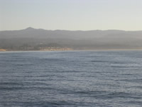
Outstanding Features of the Monterey Bay This Tuesday morning marks the beginning of our twentieth day at sea. Today and tomorrow will be our last full days on station in the bay. The crew and the science team are eager to successfully complete their assigned duties and begin the 40-hour steam back to the San Diego harbor. The science teams are using these last few days to focus on comparing incoming data from each of the three groups (the lidar, the profiler, and the echo sounder). As we send down the profiler we look to see if thin sections of plankton are occurring. The profiler presents a thin layer as a peak in green chlorophyll and a decrease in the transmission of light. The lidar team monitors their screens looking for dark layers (showing light reflected off the layers) that appear within the top ten meters of water. The echo sounder is constantly monitoring the presence of animal life (zooplankton and fish) within the entire water column to the seafloor. A layer that shows up in all three areas will help when evaluating how effective these instruments are in working together to detect thin layers of plankton. The science team has been working on a round the clock rotation of 4 hours on and 8 hours off. As I work my scheduled shifts (8 to 12) I find myself wondering at how the bay was created, and what are the names of the nearby peaks, ridges, and valleys, in this area. I looked at area maps and I read through information by H. Gary Greene that is posted on the USGS (United States Geological Survey) website. I found a lot of detailed information some of which may be of interest to the casual reader. The most awesome yet concealed feature of this bay is the Monterey Canyon. This underwater (submerged) canyon begins near the centrally located community of Moss Landing. The canyon continues westward for about 56 miles as it splits open the continental shelf of the bay. The canyon formed through erosional processes that cut deep into the otherwise flat continental shelf. Geologists have compared the size of Monterey Canyon to the Grand Canyon of the Colorado River. (Look for the picture of the canyon on this web site. The different colors represent different depths.) A second, often overlooked, feature of the bay and the surrounding landscape is the series of earthquake fault lines. These fault lines are areas where land is very slowly in slipping apart in opposite directions. These faults cut through the land and continue through the canyon. The faults in this area parallel the San Andreas Fault, which runs south to north along the length of Southern and Central California. The extensive faulting is the source of the many earthquakes that have been recorded in this area. On a clear day the dominant features of the landscape are the mountain ranges. The Santa Cruz and Gabilan mountain ranges dominate the northern end of the bay and the Santa Lucia Range towers over the southern area near Monterey. The fertile Salinas Valley is just inland from the gentle hills that smoothly roll back from the sea. It is a sharp contrast from the steep cliffs seen along most of the Southern California coastline, which we will travel along on our way back to San Diego. Math: The distance between the Monterey Bay and the San Diego Harbor is 381 miles. There are 5,280 feet in 1 mile, and 1.6 kilometers in 1 mile. What is the distance to San Diego in kilometers?
|


